
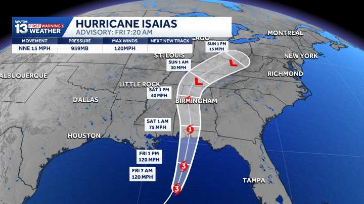
TEAM COVERAGE: Tracking Isaias’ remnants and impact
Videos show Hurricane Isaias’ impact
Current Power Outages
Track Alabama power outages with a live-updating statewide map and find out where you can report outages here.
A Flood Watch is in effect for all of Central Alabama from Friday evening through Sunday morning, with 2–4 inches of rain and isolated totals up to 5 inches possible. Monitor forecasts and remain alert for flash flooding, especially near rivers, creeks, low-lying areas, and locations with poor drainage.
What to Expect
Saturday, October 10, is an Alert Day as Isaias moves through the area.
Wind gusts could reach 40–60 mph, bringing the potential for downed trees, power outages, and difficult travel.
Rainfall totals of 2–4 inches are expected, with some locations possibly receiving more than 5 inches, increasing the risk of flooding.
Isolated tornadoes are also possible.
Severe Storm Risk
Tornadoes are possible in Isaias’ rain bands on Saturday, but as of the latest track, the risk has shifted more east.
Regardless, if they develop they will likely dissipate quickly, making them difficult to detect on radar.
Stay alert and make sure you can receive weather warnings.
Potential Rainfall
Tropical moisture will be steered northward as the system approaches the coast later this week. Even if it remains weak, the system could still bring scattered-to-widespread showers through the weekend, depending on its exact track.
Rainfall potential could change significantly over the next few days as we watch the system forming. This is one model’s opinion, but it is valuable to see it as a worst-case scenario.
For 12 consecutive years, WVTM 13 First Warning Weather has been the source for the certified most accurate forecasts in Central Alabama, showcasing an unwavering commitment to delivering dependable weather updates.WVTM 13 is available on all platforms, ensuring you can access accurate weather updates whenever and wherever you need them. Whether it’s on TV, social media or through our free mobile app, you’ll stay connected to the latest forecasts and alerts.“We always prepare you for what’s next. Warning you first to every weather change in every forecast. It’s our commitment to you.”