
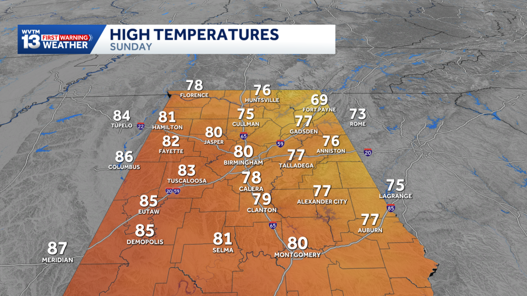
The remnants of Isaias will keep Sunday mostlycloudy, breezy, and cooler. Next week will be hot and dry again with highs pushing back into the 90s before a cold snap next weekend. Check the video forecast for the latest updates.
7-DAY FORECAST
SUNDAY: Partly to mostly cloudy, with drizzle lingering in early morning. A light breeze with a few spotty showers early. Highs in the upper 70s to lower 80s. Rain chance: 10%.
MONDAY: Fair and cooler in the morning. Still very warm in the afternoon. Highs in the 80s. Rain chance: 0%.
TUESDAY: Partly to mostly sunny. Unusually warm and dry in the afternoon following a mild morning in the upper 50s to lower 60s. Expect high temperatures around 84-88 degrees. Rain chance: 0%.
WEDNESDAY: Fair and warm. Morning lows in the 60s, afternoon highs near 90 degrees. Rain chance: 0%.
THURSDAY: Sunny, unusually warm and dry. Morning lows in the 60s, afternoon highs near 90 degrees. Rain chance: 0%.
FRIDAY: Increasing clouds. A low chance of some showers ahead of a cold front. Highs in the 80s. Rain chance: 10%.
SATURDAY: Breezy and cooler. A cold front drops temperatures back to near or just below average for mid-October. Highs in the 70s. Rain chance: 10%.
ALABAMA GAME
Good news for those attending the Alabama game Saturday evening: the worst of the weather will be long gone. You can still plan on a damp, gray evening, with a few spotty showers possible. Temperatures will be in the upper 60s at kickoff, then fall to near 63 by the end of the game.
HURRICANE ISAIAS
Hurricane Isaias made landfall near Destin, Florida, as a Category 2 storm at 8:30 p.m. on Friday, October 9, with maximum sustained winds of 105 mph. Although it weakened significantly after landfall, the storm still caused extensive damage along the coast and brought significant impacts to us here in central Alabama.
SUNDAY
Isaias’ remnants linger in north Alabama leading to spotty showers lingering early in the morning, but clouds will gradually clear through the afternoon. It will remain breezy, with wind gusts around 20 mph, with isolated areas a bit more windy.
Highs will reach around 80 degrees tomorrow with some sunshine, though wetter areas may struggle to heat up.
HEAT? AGAIN?
By Monday, that tropical moisture will move out of the picture, and we will see another week of mild mornings and unusually hot, dry afternoons under a mostly sunny sky.
That’s all thanks to another stubborn ridge building back in early this week, allowing afternoon temperatures to rise 10-15 degrees above normal.
High temperatures will rebound to the middle and upper 80s, and there will even be a chance some spots mainly over western Alabama could hit 90 degrees by mid-week.
The heat will stick around for the next 6–10 days, with the Climate Prediction Center forecasting above-average temperatures. By next weekend, however, temperatures could return to normal.
COLD SNAP
Thankfully, the heat shouldn’t last too long, because by the weekend, there are some signs of a strong cold front that will break the back of the unusual warmth by the end of next week.
Rain chances will remain limited through the week, with showers possible by the weekend ahead of a cold front.
We’re keeping rain chances low for now due to uncertainty in the front’s timing and intensity. Some guidance suggests temperatures could fall below average on a few days next week—a noticeable change after a week of highs near 90.
For 12 consecutive years, WVTM 13 First Warning Weather has been the source for the certified most accurate forecasts in Central Alabama, showcasing an unwavering commitment to delivering dependable weather updates.
WVTM 13 is available on all platforms, ensuring you can access accurate weather updates whenever and wherever you need them. Whether it’s on TV, social media or through our free mobile app, you’ll stay connected to the latest forecasts and alerts.
“We always prepare you for what’s next. Warning you first to every weather change in every forecast. It’s our commitment to you.”