
Alabama’s first widespread freeze of the season is expected Saturday and Sunday mornings. Freeze Warnings are in effect across central Alabama, and unusually cold weather will continue into early next week.
Check the video forecast for the latest updates.
7-DAY FORECAST
SATURDAY: Sunny, cold and dry after a morning freeze. Highs will reach the lower to middle 50s, with north winds around 10 to 15 mph. Rain chance: 0%.
SUNDAY: Frost and another freeze are expected in the morning. It will stay cool under sunny skies, with highs in the upper 50s to near 60 degrees. Rain chance: 0%.
MONDAY: A cold start in the 30s gives way to a milder afternoon. Highs will reach the lower 60s under sunny skies. Rain chance: 0%.
TUESDAY: Partly to mostly sunny. Morning lows will range from the 30s to lower 40s, with highs in the lower 60s. Rain chance: 0%.
WEDNESDAY: Fair and mild in the afternoon. Morning lows will be in the 40s, with highs in the mid-60s. Rain chance: 0%.
THURSDAY: Chilly in the morning, then mild and dry in the afternoon. Lows will be in the 40s, with highs near 70 degrees. Rain chance: 0%.
FRIDAY: A bit of a chill in the morning, warming up in the afternoon. Highs will top out in the lower 70s with lows in the 40s. Rain chance: 10%.
FREEZE WARNINGS
Freeze Warnings have been issued across central Alabama Saturday and Sunday mornings. Both days warnings are in effect from midnight to 8 a.m.
Temperatures are expected to fall to 28 to 32 degrees Saturday morning, though some locations may stay just above freezing. Sunday morning lows could range from 27 to 32 degrees, with light winds.
In the Birmingham metro area, temperatures could stay below freezing for two to four hours early Saturday and again early Sunday.
Farther north, Cullman, Gadsden, Jasper, Oneonta, Haleyville and Hamilton could see more than four hours of subfreezing temperatures Saturday morning and more than six hours Sunday morning.
Frost and freezing temperatures could kill crops and other sensitive plants. Unprotected outdoor plumbing may also be damaged. Cover tender plants and protect exposed pipes.
This is not extreme cold, but it is a reality check. October averaged about 4 degrees above normal, and November so far has been almost 6 degrees above normal. This kind of cold is typical for mid-November, but it may feel colder because we are not used to it yet.
Afternoon highs will stay in the mid-50s to 60s through the weekend. Sunshine will make it feel much nicer in sunny spots, while breezy conditions will keep shaded areas feeling quite cool.
FOOTBALL WEATHER
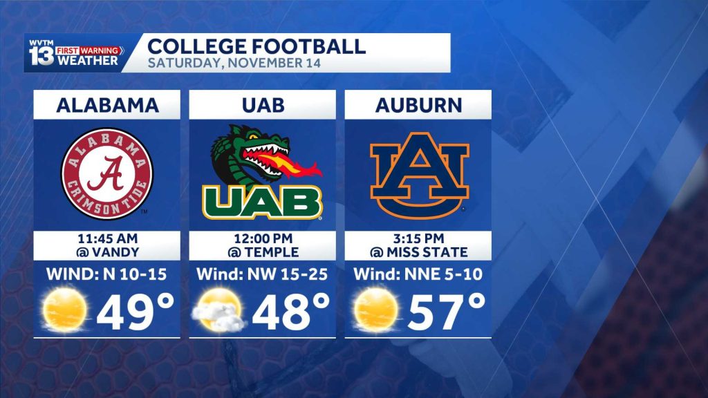
College games will feel like football weather this weekend.
Alabama at Vanderbilt: Sunshine and cool temperatures are expected at FirstBank Stadium in Nashville for the 11:45 a.m. CST kickoff. Temperatures will start near 48 degrees, reach 52 at halftime and climb to about 53 late in the game. North winds will be 5 to 15 mph.
UAB at Temple: Partly sunny skies and brisk conditions are expected at Lincoln Financial Field in Philadelphia for the noon CST kickoff. Temperatures will start near 46 degrees, reach about 48 at halftime and fall back into the mid-40s late in the fourth quarter. Northwest winds will be 5 to 15 mph.
Auburn at Mississippi State: Sunny skies and crisp fall air are expected at Davis Wade Stadium in Starkville for the 3:15 p.m. CST kickoff. Temperatures will start near 57 degrees, cool to 53 at halftime and reach about 48 in the fourth quarter. North-northeast winds will be 5 to 15 mph.
Western Carolina at Samford: Sunny skies and crisp afternoon weather are expected at Pete Hanna Stadium in Homewood for the 2:30 p.m. CST kickoff. Temperatures will reach 54 to 55 degrees around kickoff, ease to 51 at halftime and drop into the mid-40s after sunset in the fourth quarter. North-northeast winds will be around 5 mph.
Jacksonville State at Western Kentucky: Sunny skies and chilly conditions are expected at Houchens Industries-L.T. Smith Stadium in Bowling Green for the 2:30 p.m. CST kickoff. Temperatures will peak near 50 degrees at kickoff, fall into the mid-40s at halftime and drop toward 40 by the end of the game. Northwest winds will average 5 mph.
Troy at South Alabama: Clear, cool conditions are expected at Hancock Whitney Stadium in Mobile for the 6 p.m. CST kickoff. Temperatures will start near 55 degrees, fall to 49 at halftime and cool into the mid-40s late in the fourth quarter. North-northeast winds will be 5 to 10 mph.
DRY WEATHER IN THE FORECAST
You may have heard about El Niño’s impact on the season ahead, but it has not firmly taken control of the weather pattern yet. El Niño, especially a strong one, usually brings more opportunities for rain than a typical year. So far, we have seen very little.
This week’s U.S. Drought Monitor was released Thursday. Drought has worsened significantly since the very wet summer, but it has not deepened significantly over the past two weeks.
Most of north and central Alabama needs about 5 to 10 inches of rain through mid-December to end the drought. Most long-range guidance keeps El Niño’s wetter, stormier influence mainly to our south, closer to the Gulf Coast, through mid-December.
Somewhere in there, rain will return. We just cannot see it on the immediate horizon.
For 12 consecutive years, WVTM 13 First Warning Weather has been the source for the certified most accurate forecasts in Central Alabama, showcasing an unwavering commitment to delivering dependable weather updates.
WVTM 13 is available on all platforms, ensuring you can access accurate weather updates whenever and wherever you need them. Whether it’s on TV, social media or through our free mobile app, you’ll stay connected to the latest forecasts and alerts.
“We always prepare you for what’s next. Warning you first to every weather change in every forecast. It’s our commitment to you.”