
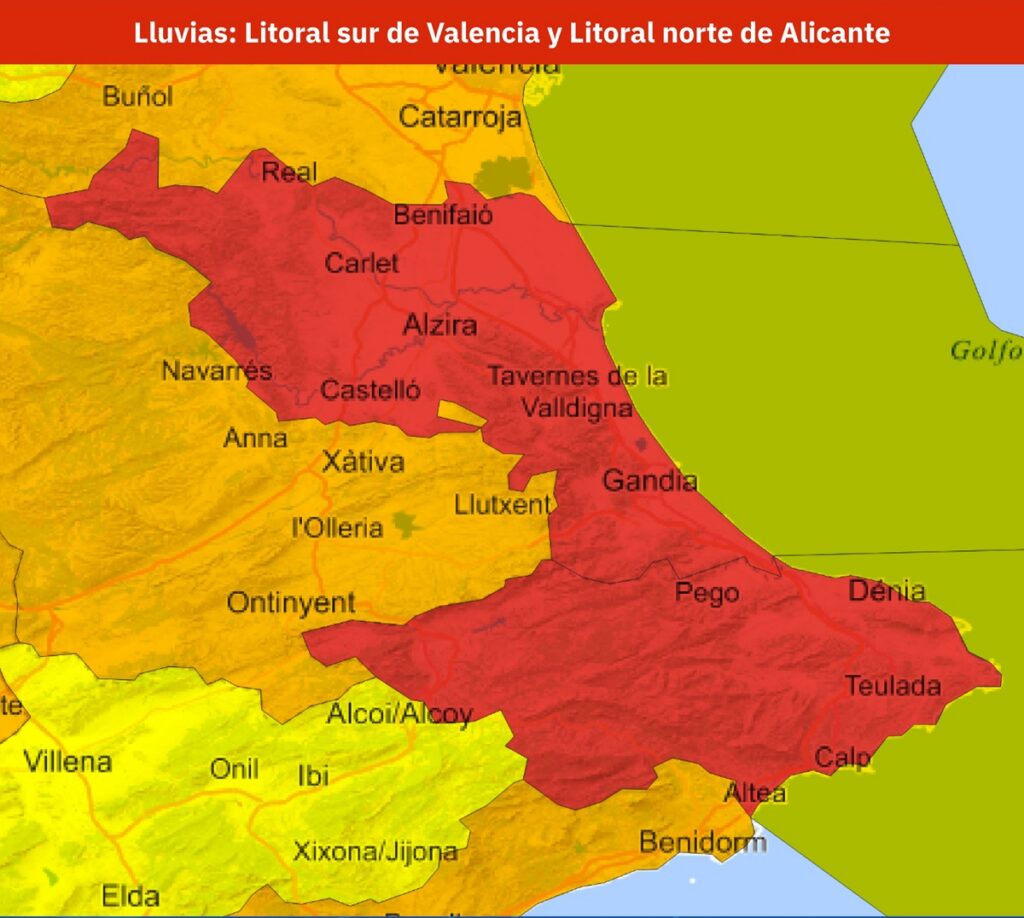
AEMET has issued a red weather alert for parts of Valencia and Alicante, with rainfall potentially reaching 300mm in 24 hours. Credit: X- AEMET
Spain’s meteorological agency has issued a red alert for some parts of Valencia and Alicante as a powerful storm system could bring torrential rain and flash flooding and dangerous weather conditions across the Mediterranean coast. The red alert was issued on Saturday, October 17, as forecasters warn that some areas could receive more than 200 litres per square metre within 12 hours. Some places could see up to 300 litres per square metre in 24 hours.
The warning is for the southern coast of Valencia province and the north coast of Alicante, where the most intense rainfall will be on Sunday, October 18 and Monday, October 19.
The State Meteorological Agency of Spain (AEMET) has declared the weather condition to be extreme, citing concerns over potential flooding, water levels in rivers and streams and dangerous driving conditions.
Most Read on Euro Weekly News
The deterioration is related to Dana Adam, the first high-impact isolated upper-level depression to be officially named this season. The system is expected to cause widespread instability in eastern Spain and the Balearic Islands over the next few days.
AVISO ROJO | Lluvias torrenciales
Litoral sur de Valencia y Litoral norte de Alicante.
Domingo 18 y lunes 19.
Más de 200 l/m² en 12 horas; en algunos puntos, 300 l/m² en 24 horas.
Situación muy adversa que puede derivar en inundaciones y crecidas de cauces.
1/2 https://t.co/SFvJ8OumSo
— AEMET (@AEMET_Esp) October 17, 2026
Red alert issued for Valencia and Alicante as rainfall could reach 300mm
AEMET enhanced its warnings on Saturday. The south coast of Valencia and the north coast of Alicante were both put on red alert due to heavy, persistent rain.
The red warning is scheduled to take effect at 10am on Sunday, and rainfall could be in excess of 200 litres per square metre within 12 hours.
In some parts of the country,rainfall could reach 300 litres per square metre during the episode.
To put those figures into perspective, one litre per square metre is equivalent to one millimetre of rainfall. This means that some areas could receive more than 200mm of rain within half a day, an amount capable of overwhelming drainage systems and causing rapid flooding.
The red warning area is an area of extreme vulnerability along the Mediterranean coast, including Gandia, Oliva, Pego and Dénia. AEMET’s official warning map can be consulted to verify the area.
Other parts of the Valencian Community are also facing significant weather risks. Orange warnings have been issued for southern Alicante, the south interior of Valencia, and other coastal areas, where rainfall may exceed 60 litres per square metre in an hour and 150 litre per 12 hours.
Although orange is one level below red, it is still dangerous. Especially in regions where rain accumulates in streets, underpasses, and dry river beds.
Residents should also be aware that warning levels may change as the weather system evolves. The most up-to-date information is available at AEMET’s official weather alerts.
DANA Adam: Why Sunday and Monday could bring the worst conditions
The approaching storm is being caused by a DANA. A DANA is a weather phenomenon that involves an isolated pocket of cold air in the upper atmosphere.
When this colder air interacts with warm, moisture-laden air from the Mediterranean, it can create powerful thunderstorms and extremely intense rainfall.
In its special weather bulletin issued on Friday, October 16, AEMET warned that DANA Adam would cause a significant change in conditions following several days of unusually warm and settled weather.
The agency also stated that a high pressure system over the British Isles would force moist easterly and north-easterly winds toward the Mediterranean coast of Spain, which would add moisture to storms.
Rain is forecast to become more widespread on Saturday. Sunday and Monday are the most dangerous days.
The largest accumulations of water would be at Cabo de la Nao, on the north coast of Alicante, and parts of Ibiza and Formentera.
Eastern Catalonia, Murcia, and other parts of the Mediterranean Coast will also be hit by heavy showers and thunderstorms. However, the warning levels vary depending on the region.
The AEMET has warned that this event could cause localised flooding, especially in low-lying areas, as well as sudden water levels in rivers, ravines, and other normally dry watercourses known in Spain as ‘ramblas.’
These risks may be greater where the ground is already saturated following earlier rainfall, reducing its capacity to absorb additional water.
Strong winds and stormy seas can also occur along the open Mediterranean coastline.
However, forecasters are still unsure where the rain will fall hardest. A small shift in the position of the DANA could change the towns that would be most flooded.
The unsettled weather is expected to improve from Tuesday, October 20, but there will still be showers along the coast.