
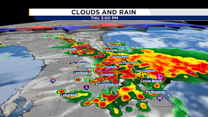
A Weather Aware Day has been issued.
Today
The News 6 Weather Team has issued a Weather Aware day for Thursday afternoon as numerous showers and thunderstorms are expected in the afternoon. Some of these storms could be on the stronger side, packing winds up to 50mph and can lead to localized flooding in low-lying areas. These storms will begin to develop around lunch time, between 12-1pm. These storms will continue to spread throughout Central Florida as the afternoon rolls on, becoming more widespread by mid-afternoon. These storms will persist through the afternoon commute and into the evening. Due to the increased instability in our atmosphere from a weak frontal boundary to our north, these showers will linger later into the evening. Scattered showers are possible through 10pm.
Friday
With energy and moisture from this front lingering, elevated rain chances stick around for Friday. Spotty storms are possible Friday morning, primarily near I-75. Storm chances spread eastward into the afternoon as storms scatter themselves across the area for the second half of Friday.
This Weekend
With another cold front approaching the Deep South into the weekend, another round of deep moisture will push into Central Florida. High rain chances persist for both Saturday and Sunday. Highs will remain in the upper 80s to low 90s. We will gradually transition back to our typical sea breeze pattern as we move into next week.
Copyright 2026 by WKMG ClickOrlando – All rights reserved.