
Alabama Impact Day: Extreme heat, severe storms Saturday and then a cooler forecast late next week
September’s blazing heat will not back down for the weekend, but there will be a break in the extremely hot weather soon. We will also have a few strong storms over the weekend. Check the video forecast for the latest updates.
7-DAY FORECAST
SATURDAY: Partly sunny and very hot again. Highs in the upper 90s with a chance of some scattered heavy thunderstorms, especially over eastern Alabama in the afternoon and evening. Coverage will be highest from 1 p.m. to 7 p.m. Rain chance: 30%.
SUNDAY: Partly sunny and hot. Scattered showers and thunderstorms possible. Highs in the middle 90s. Rain chance: 20%.
MONDAY: Fair and hot. A few scattered thunderstorms possible. Highs in the lower to middle 90s. Rain chance: 20%.
TUESDAY (FIRST DAY OF FALL): A few scattered storms, otherwise unusually hot weather continues. Highs in the lower to middle 90s. Rain chance: 30%.
WEDNESDAY: Partly sunny and still hot for late September. Highs around 90 degrees with a limited chance of some spotty showers and storms. Rain chance: 20%.
THURSDAY: Mostly sunny. Not quite as hot with highs between 85 and 90 degrees and lows in the upper 60s to lower 70s. Rain chance: 10%.
FRIDAY: Feeling a little more seasonable for late September, but temperatures remain above normal. Highs in the middle to upper 80s, lows in the 60s. Mostly sunny and dry. Rain chance: 0%
FIRST WARNING IMPACT DAY: SATURDAY’S HEAT AND STORMS
Tuscaloosa tied a record high and hit 100 degrees for the fourteenth time this summer on Friday, and Birmingham was just behind with a high at 99 degrees.
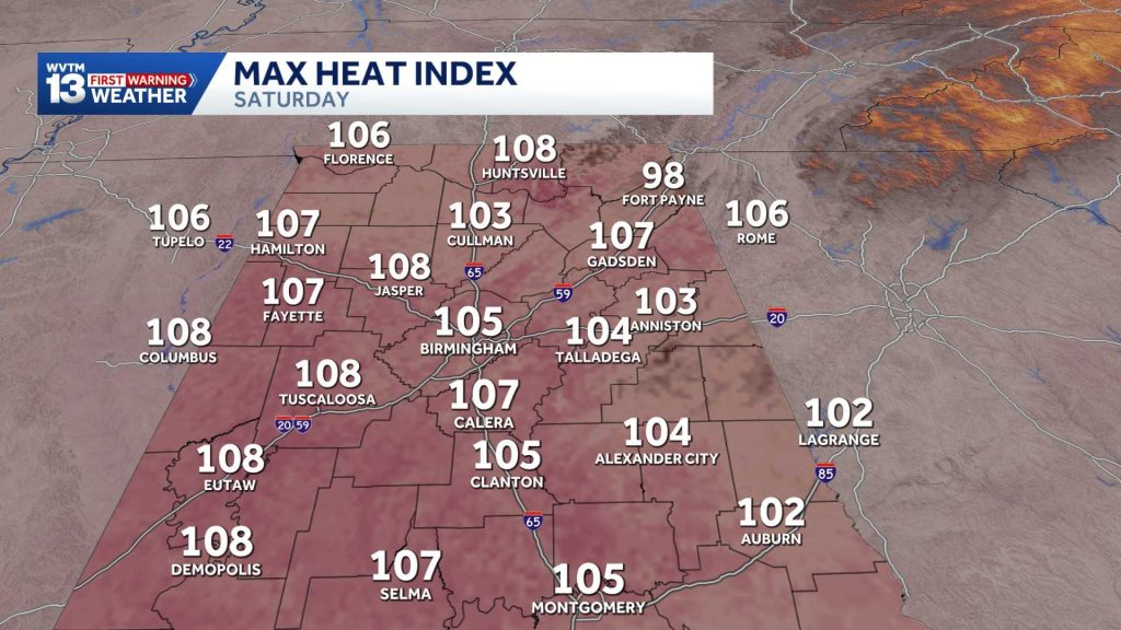
Saturday will essentially be a heat repeat, and that is why a Heat Advisory will go into effect at noon on Saturday and last until 8 p.m.
Actual air temperatures will be near 100 degrees with a heat index as high as 105 to 110 degrees—especially over western Alabama.
Farther east, there will be a better chance of some scattered, hit-or-miss thunderstorms blowing up by early afternoon from Birmingham to Anniston, Gadsden, Clanton, Sylacauga, Montgomery, Jacksonville and Auburn.
The Storm Prediction Center outlines a level one “marginal” risk of severe storms that could produce strong wind gusts over 60 miles per hour along with intense lightning and heavy rainfall.
Thunderstorms will be most likely between 1 p.m. and 6 p.m. Saturday afternoon.
RECORD SETTING HEAT
Saturday will still be hot enough to challenge some record highs.
Birmingham’s forecast calls for a high of 97 degrees, with a record high of 102 set in 1931. Tuscaloosa’s forecast high of 100 degrees will be within one degree of the record of 101, set in 1927 and 1931.
Records or not, this will be an extremely hot weekend for late September.
Sunday will remain hot, but temperatures will come down slightly. Expect highs in the lower to mid-90s, with scattered showers and storms focused primarily across eastern Alabama.
September 2026 has been the hottest on record to date surpassing the benchmark heat of September 1925. This is an extremely unusual event that is unlikely to be beaten anytime soon.
The heat will not be backing down easily despite the first day of autumn being next Tuesday. Temperatures will stay above average through the end of next week even as the pattern begins to allow for some relatively cooler air to move into Alabama.
COLLEGE FOOTBALL FORECAST
Alabama hosting Florida State: Expect partly sunny skies and intense heat for Saturday’s 2:30 p.m. CDT kickoff at Bryant-Denny Stadium. The rain chance sits near 10% at game time, rising to near 20% late in the afternoon. Kickoff temperatures will begin near 100 degrees with a light northerly breeze, sliding into the lower 90s by the fourth quarter.
Auburn hosting Florida: It will be hot with a good chance of some scattered strong storms ahead of Saturday’s 6 p.m. CDT kickoff at Jordan-Hare Stadium. The chance of rain will be around 20% by game time, but if any storms are close by, they could cause a lightning delay again this week. A light northwest breeze will accompany temperatures falling from near 84 degrees at kickoff into the upper 70s by the end of the game.
Jacksonville State hosting Georgia Southern: Pregame thunderstorms will move out before kickoff. Expect a fair, warm evening for Saturday’s 6 p.m. CDT kickoff at AmFirst Stadium. The chance of rain is around 10% by game time. The temperature will start out in the mid-80s at kickoff with light east breeze, dropping to around 80 by the fourth quarter.
Troy at Missouri: Expect hot, mostly sunny weather in Columbia ahead of Saturday’s 6 p.m. CDT kickoff. The rain chance will be around 10% with a light southerly breeze. Kickoff temperatures will start near 91 degrees, cooling near 82 degrees by the fourth quarter.
UAB at Louisiana: Clear, dry conditions and lingering late-summer heat will prevail for Saturday’s 7 p.m. CDT kickoff at Cajun Field in Lafayette. Rain is unlikely under mainly clear skies. The temperature will be near the upper 80s at kickoff with a light southeasterly breeze, cooling to around 80 by the end of regulation.
Miles at Clark Atlanta: Warm, dry conditions will greet fans in Atlanta for Saturday’s 5 p.m. CDT kickoff. Expect partly sunny skies and around a 10% chance of rain. A light easterly breeze will accompany temperatures near 90 at kickoff before temps drop to around 80 by the fourth quarter.
SIGNS OF COOLER WEATHER
Fall will officially begin in Alabama on Tuesday, Sept. 22, at 7:04 p.m. CDT.
Our forecast for fall’s arrival features fair skies, a low chance of a shower or storm and a high of 92 degrees. That is 8 degrees above average for Sept. 22.
We can finally say with confidence that this record-setting extreme September heat wave will be ending soon.
Birmingham has been above 90 degrees for 45 of the last 49 days. That will change as a weak cool front stirs up showers and thunderstorms on Monday, Tuesday and Wednesday and then allows some more seasonable air to move in by the end of the week.
Birmingham’s normal temperatures for the fall equinox on Sept. 22 are a high of 84 degrees and a low of 64.
Birmingham’s final 90-degree day of the season usually occurs around Sept. 20, but at this point, temperatures look like they will be above average through at least the first few days of October.
For 12 consecutive years, WVTM 13 First Warning Weather has been the source for the certified most accurate forecasts in Central Alabama, showcasing an unwavering commitment to delivering dependable weather updates.
WVTM 13 is available on all platforms, ensuring you can access accurate weather updates whenever and wherever you need them. Whether it’s on TV, social media or through our free mobile app, you’ll stay connected to the latest forecasts and alerts.
“We always prepare you for what’s next. Warning you first to every weather change in every forecast. It’s our commitment to you.”