
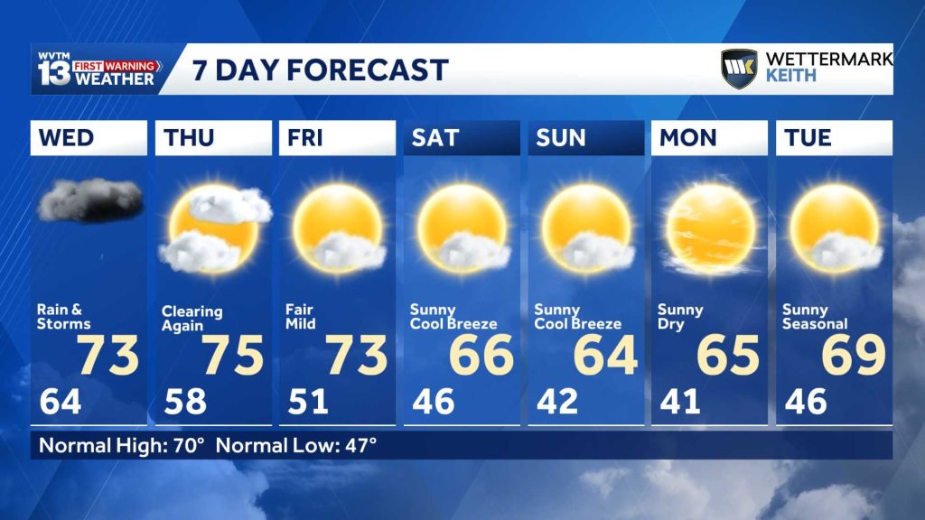
Storm chances increase heading into Wednesday, with the greatest chance for rain and storms early in the morning. A cold front will move through during the afternoon Wednesday, bringing a gradual shift to more seasonable temperatures and dry conditions through the end of the week and this weekend.
Check the video forecast for the latest updates.
7-DAY FORECAST
WEDNESDAY (IMPACT DAY): Rain and thunderstorms are likely. Most areas can expect 0.25 to 0.5 inch of rain. A few storms may bring stronger wind gusts and heavier rain, with isolated totals exceeding 1 inch. Rain chance: 70%.
THURSDAY: Clouds and a brief leftover shower are possible before sunrise. Skies will become sunny, with afternoon highs in the mid-70s. Rain chance: 10% before 7 a.m.
FRIDAY: A cool morning will give way to a sunny, pleasant afternoon. Highs will be in the low to mid-70s. Rain chance: 0%.
SATURDAY: Sunny and pleasant after a cool morning in the 40s. Highs will range from the mid-60s to the low 70s. Rain chance: 0%.
SUNDAY: Sunny and pleasant, with a cool morning and a warm, dry afternoon. Highs will be in the mid-60s. Rain chance: 0%.
MONDAY: Sunny and pleasant. Morning lows will be in the upper 30s and low 40s, followed by dry afternoon highs in the 60s. A north wind is expected. Rain chance: 0%.
TUESDAY: Cool in the morning, with lows in the 40s. Sunny skies will help afternoon highs reach the mid- to upper 60s. Rain chance: 0%.
IMPACT DAY WEDNESDAY
Through Wednesday morning, stronger storms could affect west Alabama, depending on how they hold together as they approach the state line. A low-end severe weather risk could last until 6 a.m. Wednesday.
The heaviest and most widespread rain is expected during Wednesday’s early morning commute. However, the rain will be scattered, so some areas may get a break.
WEDNESDAY OUTLOOK
Storms will be possible at times from Wednesday morning through Wednesday afternoon as they move ahead of the cold front.
The front will pass through in the midafternoon timeframe. There is a low-end chance for a stronger storm or two that may accompany the front.
While the weather setup could support stronger storms, the timing and necessary ingredients are unlikely to come together. We are not anticipating a severe weather risk Wednesday.
The cold front will move slowly, with hit-or-miss showers and occasional storms continuing for 6 to 12 hours after they begin to push into Alabama.
Rainfall totals will vary widely, with the greatest amounts likely northwest of Birmingham. Many areas there could see 0.25 to 1 inch of rain, while isolated spots could receive close to 2 inches.
Clouds and rain will keep temperatures in the low to mid-70s for much of the day.
After the front passes, skies will gradually clear. A cooler, more seasonable weekend is ahead, followed by several days without significant rain chances.
HEADED INTO THE WEEKEND
The rest of the workweek looks pleasant and sunny. Typical temperatures across Alabama this time of year range from highs of 55 to 75 degrees and lows of 35 to 55 degrees, though temperatures often fluctuate between warmer and cooler periods.
Significant cold air will not follow Wednesday’s rain. Instead, warm weather will continue through the end of the week, with afternoon highs in the 70s and overnight lows in the 40s and low 50s.
By the weekend, temperatures will move closer to normal for early November. Highs will only warm into the 60s and 70s Saturday and Sunday, with morning lows in the 40s by Sunday. The normal high this time of year is around 68 degrees, and the normal low is around 45 degrees.
By Monday morning, some areas in north Alabama could dip into the 30s, bringing a taste of winter chill. It won’t last long. Temperatures will rebound in the afternoon and gradually warm into next week.
Overall, temperatures are expected to stay above average for most of the next two weeks, generally running 5 to 10 degrees above normal.
STILL NEED MORE RAIN
Alabama is in need of a good, soaking rain. The latest Palmer Hydrological Drought Index shows that most of the state remains in a long-term drought. The state needs 4 to 8 inches of rain over the next 30 days to return to normal moisture levels.
The same pattern favors below-average rainfall in early November. That doesn’t mean we won’t see any rain, but conditions are expected to remain drier than usual as we head deeper into the month.
This dry spell doesn’t fit the typical El Niño pattern, but we’ll keep an eye on the next chance for rain.
For 12 consecutive years, WVTM 13 First Warning Weather has been the source for the certified most accurate forecasts in Central Alabama, showcasing an unwavering commitment to delivering dependable weather updates.
WVTM 13 is available on all platforms, ensuring you can access accurate weather updates whenever and wherever you need them. Whether it’s on TV, social media or through our free mobile app, you’ll stay connected to the latest forecasts and alerts.
“We always prepare you for what’s next. Warning you first to every weather change in every forecast. It’s our commitment to you.”